Read our case study about MGGP Aero and the Regional Tree Crown Map.
About the project
In this case study, dive into the groundbreaking project where MGGP Aero harnessed the power of FME Platform to process over 19TB of data, including LiDAR data, and craft the Regional Tree Crown Map, an extensive database covering over 5 billion trees in Poland.
Contents:
Established in 2001 in Tarnów, Poland, MGGP Aero specializes in acquiring vertical and oblique aerial photographs, satellite imagery, hyperspectral data, thermal images, and LiDAR data. The company excels in creating inventories, performing analyses of urban areas and the natural environment through remote sensing methods, and providing 3D modeling services.
Context
Following amendments to geodesy and cartography laws in July 2020, the Head Office of Geodesy and Cartography released its Central Geodetic and Cartographic Resource. Geospatial data resources, maps, topography and utility information, 3D models, and other resources have become publicly accessible. Among the released data, the classified LiDAR point cloud covering the entire country, acquired through airborne laser scanning, marked a crucial milestone.
MGGP Aero seized this opportunity for its research & development project, the Regional Tree Crown Map, leveraging the released point cloud and LiDAR data.
What inspired the vision for the Regional Tree Crown Map?
The inspiration behind the Regional Tree Crown Map was to provide free access to comprehensive information about Poland’s trees and their locations.
The Tree Map was created primarily for nature conservation reasons. It not only equips landscape managers with detailed tree information but also caters to residents eager to enhance their understanding of the environmental conditions in their vicinity. The provision of detailed and easily accessible data on trees across the country is indispensable for various sectors, including forestry, agriculture, environmental protection, and infrastructure planning.
Functioning as a dynamic tool, the Tree Map captures tree count fluctuations over time, empowering Polish society to make well-informed decisions about their environment. The project also poses a great opportunity to showcase the potential of aerial remote sensing, highlighting the capabilities of aerial and satellite data.

„As advocates for nature, we increasingly recognize the pivotal role trees play in the urban adaptation to climate change. Beyond their aesthetic appeal, trees are indispensable for preserving the biodiversity of agricultural spaces, safeguarding the natural environment, and enhancing our overall quality of life. Their multifaceted contributions, from mitigating noise and pollution to regulating temperature and humidity, underscore their significance. Our commitment lies in ensuring that those responsible for green spaces can effortlessly access comprehensive tree information, empowering them to make decisions that foster sustainable management of the areas they oversee.”
Martyna Wietecha, Łukasz Sławik, Dominik Kopeć, and Alicja Gadawska, MGGP Aero
The role of trees in cities
Delve into the importance of trees in the face of climate change and their economic, recreational, and protective significance:
The impact of trees on urban temperatures

A comparison of temperatures in areas with ample tree coverage versus areas with limited trees.
Challenge
Designing the Regional Tree Crown Map concept
The data released for MGGP Aero’s project was not readily available or user-friendly. This was particularly challenging due to its nature as geospatial data, distributed through intricate mechanisms. Securing free access to the data, including LiDAR, marked just the initial phase in the journey towards crafting the Map.
Several tasks demanded inception from the ground up, encompassing the definition of final parameters, generation of visualization concepts, product design, and the selection of methods for bringing the Tree Map to life. The insights gained from a prior undertaking, the Warsaw Tree Crown Map, proved instrumental in navigating these intricate tasks.
During the preparatory phases for the Regional Tree Crown Map, it became apparent that the country’s greenery inventory exhibited deficiencies. At that time, Warsaw stood as the sole large city in Poland with a detailed and comprehensive inventory of its trees.

Solution
MGGP Aero utilized the FME Platform to create and evaluate prototypes, visualizations, and concepts of the Regional Tree Crown Map.
The released data, including the ALS point cloud and orthophoto map sheets, were obtained from Geoportal. However, acquiring them posed a significant challenge:
- In total, the data equaled dozens of terabytes.
- Initially, data indexes weren’t available, prompting the use of FME to scrape addresses and create a database of all URL addresses.
- The speed of data download depended on the time of the day and the number of Geoportal users.
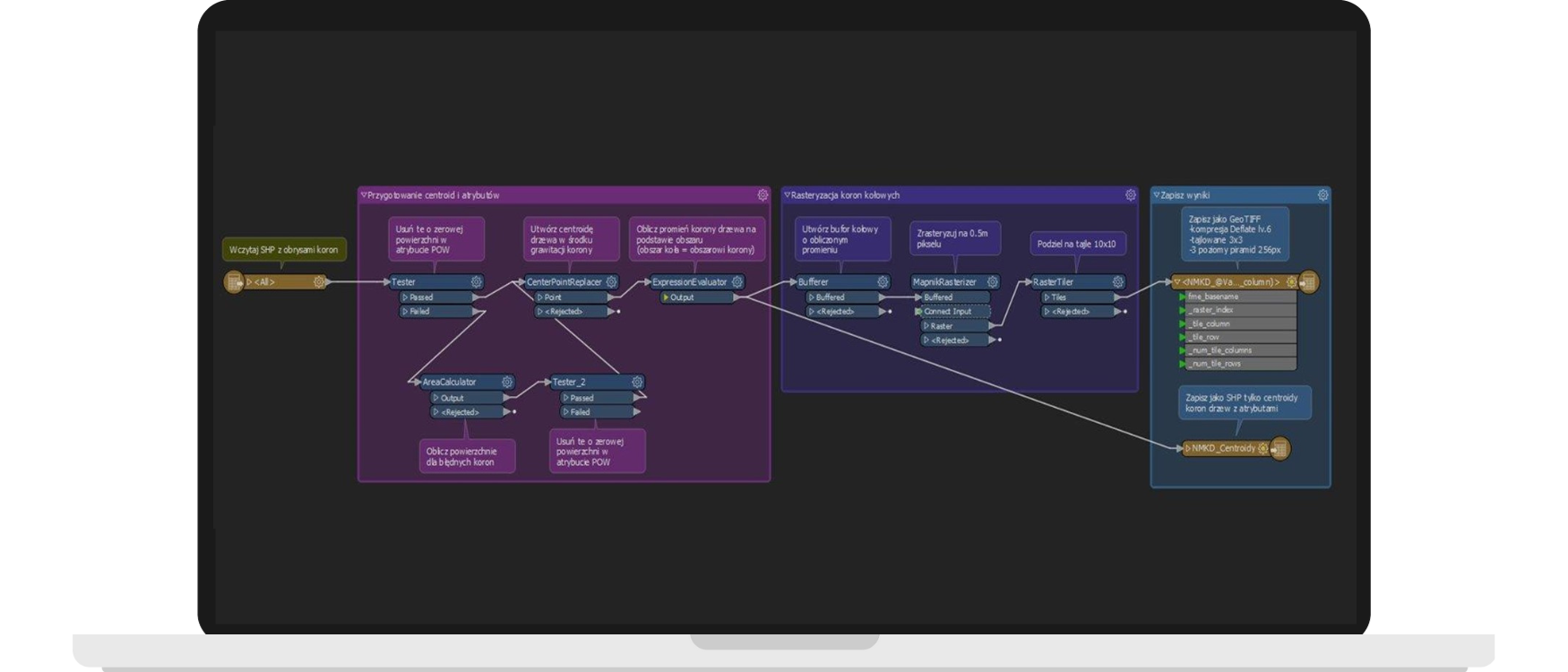
Preparing data for the Regional Tree Crown Map with FME Platform
The implementation required a substantial computational cluster. Data, including LiDAR, DTM, CHM, and orthophoto maps, were divided into several disk arrays.
FME Platform was instrumental in:
Managing the production database
Tracking the processing progress
Orchestrating external processes
Combining results into a single database
Controlling the processed data quality
As a result, MGGP Aero created:
A tree database
A tree crown reach database
Quantitative and area statistics
A raster visualization in the web app
A map background including the orthophoto map
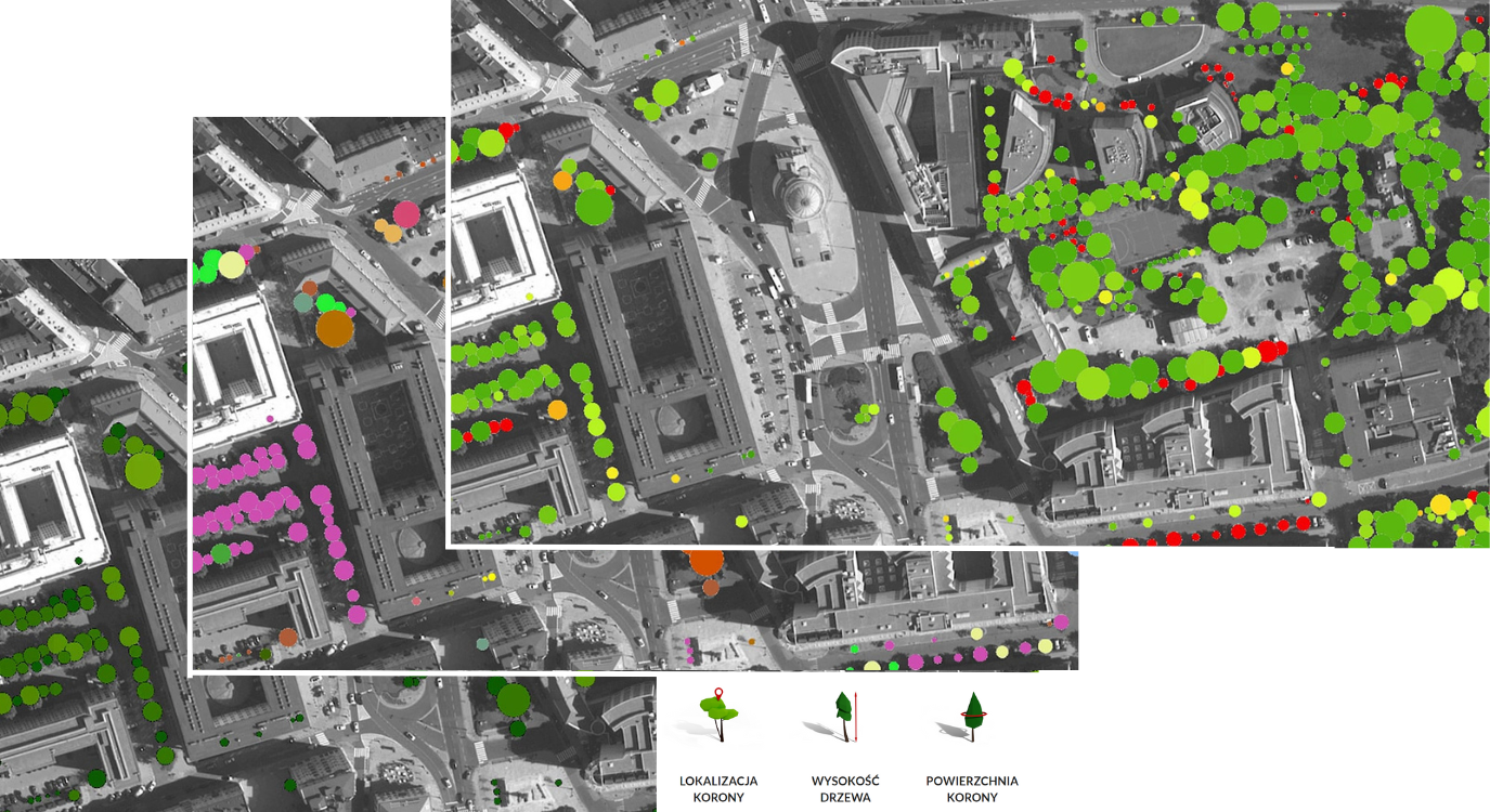
The Regional Tree Crown Map presenting trees, including parameters such as locations, crown dimensions, heights, etc.
Results
On October 5th, 2021, The Regional Tree Crown Map was launched at www.mapadrzew.com
The website was crafted using the OBLIVIEW® technology developed by MGGP Aero since 2019. The solution is publicly available through an open web app and a mobile app, with plans for further development in the crowdsourcing model.
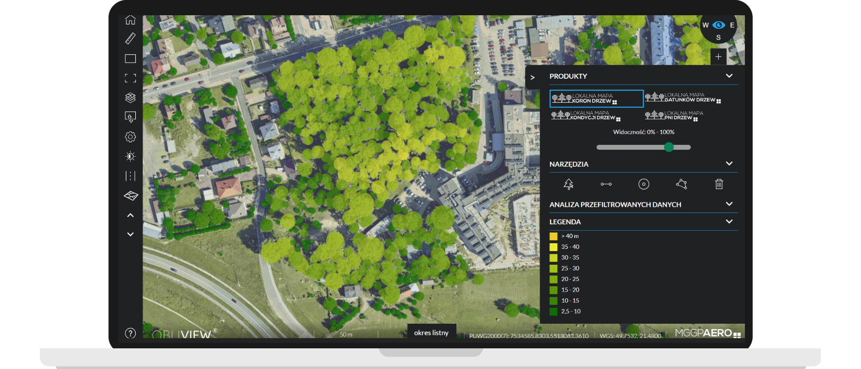
The tree height map in the Regional Tree Crown Map application
The Regional Tree Crown Map stands as the most thorough, free database about Polish trees. It includes information about more than 5 billion trees over 4 meters tall and with a crown of over 9 square meters wide. The information encompasses tree locations, heights, as well as crown dimensions and volumes. Additionally, the Map presents the number of trees and total tree crown surface dimensions within an area defined by the user or in defined height ranges. The Map also allows users to analyze tree crown locations in regards to roads, land lots, borders, and buildings.
Additionally, paid access to the service provides an option to calculate statistics for larger numbers of trees and download a selected Map area as a vector layer.

Tree parameters on the Regional Tree Crown Map™

Fun fact
The Douglas fir “Helena” is one of the tallest trees in Poland, measuring 59.4 meters.
- Species: Pseudotsuga menziesii
- Height: 59.4 m
- Age: about 120 years
- Diameter at breast height: 349 cm
- Crown span: 12 m
- Height of the trunk base above sea level: 343.5 m

In 2021, the Regional Tree Crown Map won first place in the Head of Geodesy and Cartography competition. The map was named the best project using open data in the category “Publically available app or website using data and services provided by the Head Office of Geodesy and Cartography”.
The Regional Tree Map in numbers:
MGGP Aero processed
19TB of data
The used point cloud covered
1 523 995 330 400 points
The company created an inventory of over
5 billion trees

The great computing capabilities of our Data Production Center adeptly managed vast volumes of data – 19TB, to be precise. Leveraging the power of the cloud with extensive 1 523 995 height points enabled us to pioneer a tree map that’s unique on the European scale. We tallied every tree in Poland, capturing details such as heights, crown outlines, and precise locations. In total, we inventoried over 5 billion trees.
Karol Krajewski and Łukasz Sławik, MGGP Aero
Ogromna moc obliczeniowa naszego Data Production Center całkiem szybko uporała się z gigantyczną ilością danych (19 TB). Dzięki chmurze punktów wysokościowych, których dla całej Polski było 1 523 995 330 400, udało nam się opracować unikalną w skali europejskiej mapę drzew. Mamy policzone wszystkie drzewa w Polsce, znając ich wysokość, zakres obrysów koron oraz dokładne położenie. Łącznie zinwentaryzowaliśmy ponad 5 mld drzew.
Karol Krajewski, Łukasz Sławik, MGGP Aero
Would you like to achieve similar results?
If your organization seeks similar achievements, consider the transformative potential of FME. Fill out the form and our consultants will help you uncover FME’s value for your needs.
You can also reach out to us via e-mail or phone:
fme@globema.pl
+ 48 22 848 73 13

Explore other success stories
GEOPOZ
Transforming urban spatial data with FME. Case study of GEOPOZ’s innovations
Learn how the Board of Geodesy and City Cadastre (GEOPOZ) in Poznań used FME to construct a dynamic 3D city model, an urban forestry database, and a range of other pioneering solutions.
MPU Łódź
E-services, reports, and local zoning plans
Learn how the Municipal Planning Office in Łódź uses the FME Platform to create local zoning and land use plans, spatial analyses, and new solutions.